Recent advancements in satellite technology have allowed for an unprecedented mapping of the ocean floor, showcasing a level of detail that has not been seen before. This week, NASA released a video demonstrating a clearer depiction of the ocean’s depths, facilitated by observations from space.
Historically, the lunar surface has been mapped with greater precision than Earth’s seabeds. However, the launch of the Surface Water and Ocean Topography (SWOT) satellite by NASA in collaboration with the French space agency CNES in 2022 marks a turning point. Research efforts culminated last December with the publication of a groundbreaking study in the journal Science, utilizing one year of data from the SWOT satellite.


Historically, the lunar surface has been mapped with greater precision than Earth’s seabeds.
The SWOT satellite addresses significant information gaps previously noted in data gathered from ships, providing a higher resolution view than its predecessors. These enhanced maps could aid in safer navigation for submarines through once-unknown ocean landscapes and support the delicate operations of installing and maintaining undersea telecommunication cables that connect people around the globe.
Additionally, the new NASA video offers an engaging experience, depicting seafloor features along the coasts of Mexico, South America, and the Antarctic Peninsula. Ongoing research using SWOT data is expected to unveil further discoveries about the ocean’s depths in the future.
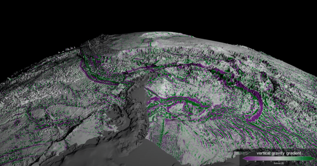
The newly generated maps utilize gravity measurements to reveal previously unobserved features. Areas such as abyssal hills and seamounts, which have increased mass, create a stronger gravitational pull than their surroundings. By analyzing these slight variances, SWOT can depict such features by observing surface manifestations in the water. In the accompanying video, regions designated in green indicate higher elevations compared to those colored in purple.
This innovative approach enables SWOT to identify abyssal hills and various features that older satellites could not detect effectively. “We were amazed at the clarity with which SWOT interpreted these structures,” said Yao Yu, an oceanographer from the Scripps Institution of Oceanography and lead author of the Science paper in a recent NASA blog post. Researchers have now updated their understanding, revealing that such hills, formed by tectonic plate movements, cover about 70 percent of the ocean floor, making them the most prevalent landform on the planet, according to Yu.
While ships equipped with sonar can also chart these abyssal hills, the process is slow and labor-intensive, with only about a quarter of Earth’s ocean floor mapped to date.
SWOT’s mission extends beyond seafloor mapping. Its primary goal is to measure the heights of water across oceans, rivers, lakes, and other water bodies, undertaking the first comprehensive survey of Earth’s surface water.

